The wind tore off part of the roof of the shopping center in the south of the city. Find out what caused the storm and the forecast for the weekend.
The storm that hit the city of Sao Paulo this evening, October 11, arrived with heavy rain and gusts of wind that exceeded 100 km/h. Heavy rain quickly caused flooding and wind caused roof damage and tore off part of the roof of SP Marketing Shopping in the south of the city.
São Paulo/Jardim Jabaquara, by Allef Matos, 10-24-11: destruction due to wind speeds exceeding 100 km/h
It was precisely in the southern area of the capital Sao Paulo where the most intense gusts of wind were recorded. The National Institute of Meteorology measured up to 108 km/h per hour in the Interlagos region. However, based on the damage observed in the various videos rapidly circulating on social media, the gusts of wind exceeded this value in some points in the southern area of the city.
The images below are reproductions of videos shot by Climatempo meteorologist Allef Matos, who witnessed the damage in the Jardim Jabaquara region.

Sao Paulo/Jardim Jabaquara by Allef Matos, 24-10-11: destruction caused by winds with speeds exceeding 100 km/h
What caused the storm?
The storm in the São Paulo region was caused by the passage of a cluster of cumulonimbus clouds. These clouds formed this Friday in many locations in the state of Sao Paulo and were responsible for heavy rain, strong gusts of wind and lightning.
This type of cloud is quite common in Brazil and forms when there is great availability of humidity and a warm atmosphere. This situation was observed throughout the state of Sao Paulo this Friday.
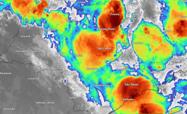
Furthermore, the formation of these cumulonimbus clouds was stimulated by the passage of a cold front along the coast of São Paulo, by the presence of low atmospheric pressure between Paraguay and Mato Grosso do Sul and by the trend of hourly circulation around 5 km above the surface . Part of the clouds formed in the state of Sao Paulo itself and others came from Mato Grosso do Sul

Large red spots indicate very heavy clouds, of the cumulonimbus type, with thunderstorm potential (Image: GOES 16 – windy.com)
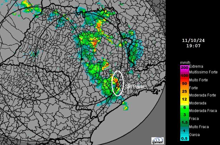
The very heavy clouds that flew over the Sao Paulo region on Friday night came from the Sorocaba region, as shown in the IPmet/Unesp weather radar image. The cumulonimbus cloud cluster appears as a red/orange spot within the white outline.

The storm clouds that passed over Sao Paulo appear in red/orange tones within the white outline (Source: IPmet/Unesp)
Wind
The wind that spread over the city of Sao Paulo together with the heavy rain scared many people. In some places strong gusts of wind caused damage to the roof.
The National Institute of Meteorology has recorded a gust of 108 km/hbetween 7.00 pm and 8.00 pm, at the meteorological station of Interlagosin the southern area of the capital San Paolo.
In the North Zone, Campo de Marte airport recorded a gust of 88 km per hour at 7.44pm. Also in this area of the city, the Mirante de Santana meteorological station, managed by Inmet, recorded a speed of 75 km/h between 7 and 8 pm.
Congonhas airport had a gust of 77km per hour at 7.40pm.
Heavy rain
The heavy clouds that crossed Greater São Paulo quickly caused intense rain. Many neighborhoods in the capital of São Paulo and municipalities in the São Paulo metropolitan area recorded 10 to 20 million rainfall in just one, between 7pm and 8pm. After 8.30pm the rain had already significantly reduced
Around 8.40pm, the Climate Emergency Management Center of the Municipality of São Paulo – CGE – maintained the alert for an imminent overflow of the Água Espraiada stream and Ponte Rasa (Penha). All regions of the city of Sao Paulo remained on flood alert.
Heavy rains have so far caused 6 floods in the city, of which 3 were impassable, according to the CGE
Source: Terra
Rose James is a Gossipify movie and series reviewer known for her in-depth analysis and unique perspective on the latest releases. With a background in film studies, she provides engaging and informative reviews, and keeps readers up to date with industry trends and emerging talents.


![TOMORROW BELONGS TO US IN ADVANCE: THE PHILIPPINES WILL DO EVERYTHING TO PROTECT CHARLES… WHAT’S AHEAD OCTOBER 27 TO OCTOBER 31, 2025 [SPOILERS] TOMORROW BELONGS TO US IN ADVANCE: THE PHILIPPINES WILL DO EVERYTHING TO PROTECT CHARLES… WHAT’S AHEAD OCTOBER 27 TO OCTOBER 31, 2025 [SPOILERS]](https://fr.web.img6.acsta.net/img/b2/7f/b27f5a3fbc55d29b821eff36e2cd8a48.jpg)


-soq6i9m0ttgh.jpg)

