Find out some facts you need to know about this extratropical cyclone so as not to fall for the false news that is circulating.
Between Wednesday and Thursday 24 and 25 October, a strong drop in atmospheric pressure is expected over northern Argentina and, throughout Thursday, cyclogenesis and frontogenesis should occur, i.e. the formation of a cold front (frontogenesis) and an extratropical cyclone (cyclogenesis ).
The sharp drop in atmospheric pressure between Paraguay, Brazil, Argentina and Uruguay on Wednesday and Thursday, which will subsequently generate the extratropical cyclone, facilitates the formation of strong rain clouds in southern Brazil.
Find out some important things you need to know about this extratropical cyclone.
Extratropical cyclone and cold front between Paraguay, Brazil, Argentina and Uruguay, on 25/10/24
1 -Is it true that there will be a cyclone in Brazil this week?
That’s true, but it will only form on Thursday, October 24, between Rio Grande do Sul and Uruguay, and will quickly move away into the high seas during Friday, October 25.
2 – What is an extratropical cyclone?
It is a region of the atmosphere, outside the tropical region of the Earth, where atmospheric pressure is very low, at various altitudes, and there is circular, clockwise wind movement (the same direction as the hands of an analog clock).
The lower the air pressure, the more intense the movement of air from bottom to top. near the region where the low pressure center is located. This means that cumulonimbus clouds, which have the potential to cause thunderstorms, are more likely to form.
Furthermore, when atmospheric pressure decreases greatly in one region, the difference with atmospheric pressure in regions near the low center increases. The greater this difference, the greater the contrast, the greater the wind speed.
Extratropical cyclones are very common weather systems in Uruguay, northeast Argentina and Rio Grande do Sul. They can form over this part of South America, but can also accompany cold fronts coming from Antarctica.
3 – Is this extratropical cyclone strong?
So far, atmospheric simulations from computer forecast models, both the European model (ECMWF) and the US model (GFS), indicate that this extratropical cyclone will be strong.
The atmospheric pressure at the center of the low pressure associated with this cyclone must reach a value less than 1000 hectopascals (hPa), which is a measure of air pressure. (Temperature can be measured in degrees Celsius, for example, and atmospheric pressure in hectopascals.)
Technically, any a low pressure with 1000 hPa or less is considered a potentially dangerous low pressure cause strong winds and develop large clouds, of great vertical extension, which are thunderclouds.
4 – Is there a risk that this cyclone will pass from the South and South-East?
This cyclone will form on Thursday 24 October between Rio Grande do Sul and Uruguay, and will move rapidly out to sea on Friday 25 October, already moving away from Brazil.
The extratropical cyclone will not pass over the south or south-east of Brazil and will not advance along the south and south-east coast.
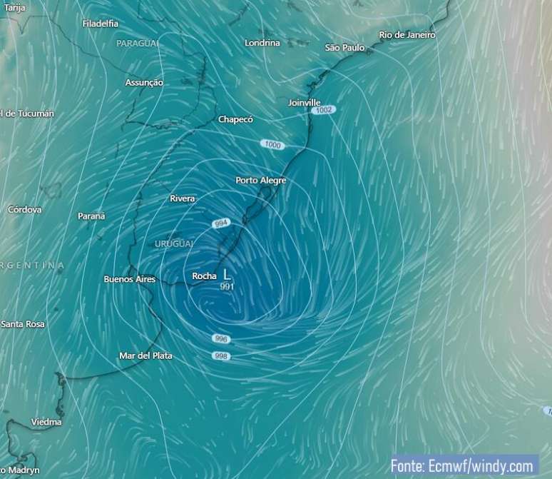
Track of the extratropical cyclone
It is important to clarify that this extratropical cyclone will not advance to the coasts of South and South-East Brazil.
The forecast is that the system will form on Thursday 24 October and in the early hours of Friday 25 it will be over the sea, near the coast of Rio Grande do Sul. On Friday the extratropical cyclone will move into the high seas, always at the height of Rio Grande do Sul, always moving away from the continent.

Estimated extratropical cyclone positions on October 24 and 25, 2024 (Source: Windy)
As the cyclone moves offshore, its effects weaken both on land and in areas near the coast. The gradual retreat of the cyclone towards the high seas causes winds to weaken in areas near southern Brazil throughout Friday.
Therefore, this extratropical cyclone will not pass along the coast of São Paulo, Rio de Janeiro or Espírito Santo.
Gusts of wind
This new extratropical cyclone, which is expected to organize on Thursday between Rio Grande do Sul and Uruguay, could cause strong gusts of wind, regardless of the occurrence of rain.
On Thursday, the possibility of strong wind gusts, between 70 and 90 km/h, directly associated with this extratropical cyclone will be taken into account, especially over Rio Grande do Sul and Santa Catarina. This estimate is preliminary and will be re-evaluated as the cyclone develops.
However, the effects of the extratropical cyclone’s wind circulation go beyond these two states and can be felt in areas of western and southern Paraná, Paraguay, and western and southern Mato Grosso do Sul.
In most of Paraná, the states of São Paulo, Rio de Janeiro and Sul de Minas could experience strong gusts of wind linked to the movement of this cyclone on Friday, which will already be over the open sea, moving away into the high seas.
Rough sea
Furthermore, the passage of the extratropical cyclone in the far south of Brazil will leave the sea rough. This is a fairly common situation. The strong winds caused by extratropical cyclones make the sea rough and cause the waves to risewhich increases the risk of possible hangovers.
An increase in waves on the southern and south-eastern coast is therefore expected by the end of this week.
During Thursday 24 October, the rough sea and rising waves It should begin to be observed especially on the coast of Rio Grande do Sul, but during the day the disturbance at sea will also extend to the offshore areas of the coast of the Southern Region, in Sao Paulo and Rio de Janeiro.
A significant increase in waves on the coasts of Sao Paulo and Rio de Janeiro is not yet expected on Thursday.
During Friday, and especially on the weekend, the wave elevation on the beaches of the entire Southern Region, São Paulo, Rio de Janeiro and the south of Espírito Santo, even if the extratropical cyclone is already far from the Brazilian coasts. There is risk of hangover.
Seas are expected to remain rough early next week.
Source: Terra
Rose James is a Gossipify movie and series reviewer known for her in-depth analysis and unique perspective on the latest releases. With a background in film studies, she provides engaging and informative reviews, and keeps readers up to date with industry trends and emerging talents.


![Un Si Grand Soleil Preview: Episode Summary for Wednesday, October 29, 2025 [SPOILERS]](https://fr.web.img3.acsta.net/img/58/48/5848773b26761cb500901ca4a1395bb8.jpg "Un Si Grand Soleil Preview: Episode Summary for Wednesday, October 29, 2025 [SPOILERS]")
