Curitiba, São Paulo, Campo Grande, Belém and São Luís are among the capitals that could experience storms this Tuesday
Cloud cover over Brazil
The presence of a cold front on the coast of São Paulo spreads areas of instability on this state and also on areas of Rio de Janeiro, Minas Gerais, Mato Grosso do Sul, Paraná and Santa Catarina. Another cold front arrives this Tuesday on the coast of Rio Grande do Sul.
Warm, humid air continues to dominate Brazil, spurring thunderstorm cloud formation over the Midwest, North, and parts of the Northeast region. The Intertropical Convergence Zone remains active on the northern coast of Brazil and brings more storm clouds to these two regions.
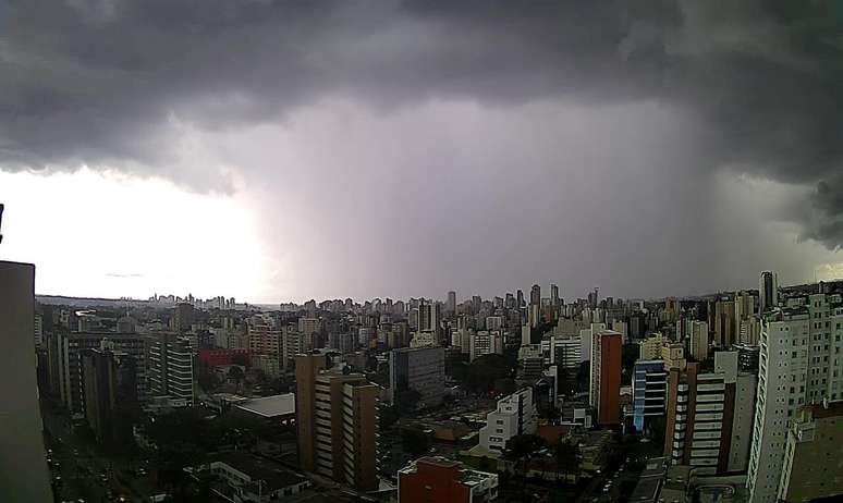
Storm over Curitiba (PR) by Climaaovivo
Weather forecast for 04/18/2023 – Tuesday
South Region
The sand of instability continues to affect Brazil’s southern region on Tuesday. Most areas of the region have plenty of cloud and rain conditions.
The rains are more frequent and can be heavy in Paraná, in the Itajaí Valley and on the northern coast of Santa Catarina. In the other areas of Santa Catarina, in the north and on the coast of Rio Grande do Sul, and in the Uruguayan region, in the southwest of the state, the sun is shining, but there may still be some showers.
A sun predominates in the other areas of Rio Grande do Sul.
With excessive cloudiness and rain, the temperature in the South is already dropping, but the cold is not intense.
Attention: from this Wednesday a sudden drop in temperature begins to occur with the entry of a strong mass of cold air of polar origin on the south of the country.
Southeast region
Tuesday with strong and hot sun throughout Espírito Santo, north-central and east of Minas Gerais and north of Rio de Janeiro.
Northern Minas Gerais is expected to be among the hottest regions in the country this Tuesday, with temperatures ranging between 35C and 37C.
The entire state of São Paulo has a Tuesday with lots of clouds and showers that can happen several times during the day. There is a risk of heavy rains in all regions of São Paulo and the south of the state can have quite heavy rains.
There is a risk of thunderstorms this Tuesday also in greater São Paulo
Tuesday with sun, heat and showers with lightning starting in the afternoon in the Triângulo Mineiro, in greater Belo Horizonte, in the south of Minas, in the Zona da Mata of Minas Gerais and in the state of Rio de Janeiro, with the exception of Nord Fluminense.
Midwest region
The states of Mato Grosso, Goiás and the Federal District have several hours of strong sunshine this Tuesday, but with the heat and high humidity, showers with lightning again occur in the afternoon and evening. These showers are expected to be short-lived.
In Mato Grosso do Sul, the situation is alert due to the formation of thick clouds that can cause heavy rain showers in all regions of the state.
Rains can occur at any time of day and are expected to be more abundant in southern Mato Grosso do Sul.
Region North East
The Intertropical Convergence Zone remains very active on the northern coast of Brazil and spreads thunderstorm clouds over part of the northeastern region.
Rain showers remain frequent and strong over Maranhão, north-central Piauí, Ceará, Rio Grande do Norte and Paraíba. In eastern Pernambuco and along the coast from Alagoas to the Recôncavo Baiano region, the sun appears strong, but it can rain quickly. Strong sun, dry and very hot weather in other areas of Bahia, in the south of Piauí, in the sertão of Pernambuco and in the interior of Sergipe de Alagoas.
Northern region
Many storm clouds continue to form over northern Brazil. In addition to high humidity and heat, the Intertropical Convergence Zone is very active on the northern coast of Brazil
This Tuesday is a very rainy day in Amapá, in Pará, in Roraima, in the north and east of the Amazon. Rain showers are frequent in these areas. The rest of the northern region has more showers interspersed with sunny spells.
Weather alerts for 04/18/2023 – Tuesday
Beware of the risk of pouring rain in the capitals Florianópolis, Curitiba, São Paulo, Rio de Janeiro, Campo Grande, San Luís, Teresina, Fortaleza, Natal, João Pessoa, Recife, Belém, Macapá, Boa Vista, Manaus, Porto Velho.
Special warning: danger of thunderstorms and heavy rainwith a higher risk of unrest for the population in northern Amapá (region that includes Oiapoque), southern São Paulo and northern Paraná.
storm warning on the coast of Pará (except in the east of the state), in north-central and east of Paraná, in the Itajaí Valley (SC), in south-central and east of Mato Grosso do Sul, in central, west and central-east of São Paulo, Amapá, east of Amazonas, in Roraima, north of Rondônia, coast of Maranhão, Ceará, Piauí, Rio Grande do Norte and Paraíba, sertão of Paraíba and Ceará,
Beware of the risk of moderate to heavy rains, with lightning and sometimes strong winds Santa Catarina (except in the Itajaí Valley), northern São Paulo, southern Minas Gerais, Zona da Mata Mineira, Triângulo Mineiro, central and southern Rio de Janeiro, southern Goiás, ‘west and in the north of Mato Grosso do Sul, in the north of Mato Grosso, in the east of Pará, in the Tocantins, in the Amazon (except in the east and in the extreme south of the state), Acre and south- central Amapa.
Source: Terra
Rose James is a Gossipify movie and series reviewer known for her in-depth analysis and unique perspective on the latest releases. With a background in film studies, she provides engaging and informative reviews, and keeps readers up to date with industry trends and emerging talents.


