The RS Environment and Infrastructure Secretariat (SEMA) has issued a special warning for large volumes of rain and risk of flooding in the state.
The circulation of winds at various levels of the atmosphere has maintained an atmospheric blockage situation that has forced the formation of many areas of instability over Rio Grande do Sul and Santa Catarina since the beginning of this week. Several areas in the two states have received high daily volumes of rain in recent days.
The situation worsens between this Friday 5 and Sunday 7 May, with the advance of an area of low atmospheric pressure on the region between Rio Grande do Sul, Uruguay and Argentina and later formation of a cold front.
Large volumes of rain are still expected in the next three days, especially on Rio Grande do Sul, and for this reason the Secretariat for Environment and Infrastructure of the Government of Rio Grande do Sul (SEMA) issued a special warning this Thursday . , May 4, due to the increased risk of rapid river level rise and other meteorological phenomena that could cause disruption to the people of Rio Grande do Sul.
Increased risk of flooding
According to SEMA, the main rivers of Rio Grande do Sul are at low levels (below the N75), with the exception of the Taquari River, which has normal levels for practically its entire length.
But with the expectation of large amounts of rain in a few daysthere is the possibility of changing the current hydrological conditions, with the incidence of runoffs in lower-order river stretches, where rainfall has a high volume in a short period of time, and flooding in higher-order watercourses.
Because of heavy rain in the next few daysSEMA has brought the hydrological condition to the status of attention for the Apuaê-Inhandava, Alto Uruguai, Turvo-Santa Rosa-Santo Cristo, Ijuí, Piratinim, Butuí-Icamaquã, Baixo Jacuí, Taquari-Antas and Caí basins.
Heavy rain forecast
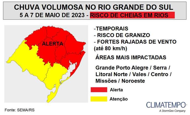
In this On Friday 5 May the areas of instability intensify throughout the day on Rio Grande do Sul due to the advance of an area of low atmospheric pressure. Risk of thunderstorms with possible hailstorms and wind gusts of 50 to 80 km/h in central and northern areas of the state. Moderate to heavy rain events, in a short period of time, can cause inconvenience to the population.
On average, the largest volumes are expected to vary between 60 mm and 80 mm in 24 hours, occasionally reaching 120 mm, especially in the regions of the Northwest, Missões, Centro, Valli, Grande Porto Alegre and parts of Serra Gaúcha and the northern coast.
To the On Saturday 6 the rains continue to affect the statestill with the risk of isolated thunderstorms in the northern half and with significant high accumulations, between 40 mm and 70 mm on the northwest, center, valleys and east of Rio Grande do Sul.
To the Sunday 7 Maythere’s a frontogenesis with cyclogenesis, which is the formation of a cold front associated with an extratropical cyclone. This will again reinforce areas of instability on Rio Grande do Sul, with the risk of storms and heavy rains in most areas.
There are still conditions for high daily rainfall volumes of between 30mm and 60mm in the Missões and Center region of the state.
The trend towards Monday, 8, is that it still rains in a generalized way in the northern part of Rio Grande do Sul. But in south-central Rio Grande do Sul, the rain is gradually losing strength as the cold front recedes.
Source: Terra
Rose James is a Gossipify movie and series reviewer known for her in-depth analysis and unique perspective on the latest releases. With a background in film studies, she provides engaging and informative reviews, and keeps readers up to date with industry trends and emerging talents.


