Summer in the Northern Hemisphere is the prime time for the transport of dust from the Sahara to the tropical North Atlantic. The dust inhibits the formation of hurricanes.
The month of June 2023 already had two named tropical storms, Bret and Cindy. Second dr. Rick Knabba hurricane specialist for the Weather Channel, from the United States, quoted on a NASA website, this was the first time more than one tropical storm organized in June, in the major North Atlantic development region.
But Bret and Cindy’s lives won’t last long. According to the US National Hurricane Center (NHC), at 00:00 Brasilia (03:00 UTC) on Saturday, June 24, Bret passed north of Aruba, Bonaire and Curaçao and is expected to dissipate overnight this Saturday.
Tropical Storm Cindy was staged, with sustained winds of 85 km/h, with major gusts, moving west/northwest with 24 km/h. The NHC forecast predicts that Cindy will strengthen somewhat this Saturday morning, June 24, but not reaching hurricane strength, and will weaken by Monday.
Bret and Cindy have not found favorable atmospheric conditions for their developments. One reason could be the dust that is spreading across the tropical North Atlantic. This dust comes from the Sahara desert and is carried by winds to the North Atlantic.
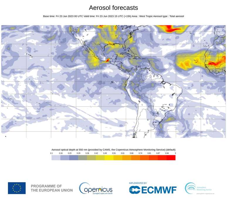
They represent yellow and red blotches flowing from North Africa to the northern tropical Atlantic
dust from the Sahara (Image: CAMS-Copernicus)
The layer of dust above the ocean makes the air drier and can reduce the sea surface temperature by about 1°C. It also causes an increase in the variation of winds at altitude, which is another factor that inhibits the growth of hurricanes.
More dust in the North Atlantic over the next few days
A large plume of dust from the Sahara Desert in North Africa is expected to drift over the tropical North Atlantic in the coming days.
The animation of the maps shows the simulation of the movement of the aerosol plumes carried out by the computational model of dispersion of pollutants CAMS (Copernicus Atmosphere Monitoring Service), of the Copernicus agency of the European Community.
The patches in shades of yellow, orange and red that roll out of North Africa and advance across the tropical North Atlantic represent Saharan dust being carried from west to east by the trade winds. The closer to red tones, the denser the layer of powder.
Does the powder get wet?
Shouldn’t powder get wet when it goes into the sea? Most of this dust doesn’t travel near the surface of the sea. Most of the time, this dust plume travels high in the atmosphere. But in some situations the layer of dust is very dense and causes disturbances on the surface, covering the cities, reducing visibility.
Around the same time, June 23/24, but in 2020, there was a transport of dust from the Sahara to the tropical North Atlantic which attracted a lot of attention because it was very dense and extensive.
At 17:00 (Brasilia time) on June 23, 2020, weather information from Kingston Airport, Jamaica showed that there was dust there. It was possible to verify the veracity of this information through the coded message called METAR, which hundreds of airports emit every hour, all over the world. Dust appears coded as DU, from dust, which is dust in English.
METARS: MKJP 232000Z 13020KT 5000 DU FEW024 32/26Q1012
When does dust from the Sahara go to the North Atlantic?
Dust transports from the Sahara to the tropical North Atlantic Ocean occur annually and are densest and most frequent during the Northern Hemisphere summer (Southern Hemisphere winter). But they can also occur in the spring and part of the fall in the northern hemisphere.
Source: Terra
Rose James is a Gossipify movie and series reviewer known for her in-depth analysis and unique perspective on the latest releases. With a background in film studies, she provides engaging and informative reviews, and keeps readers up to date with industry trends and emerging talents.


