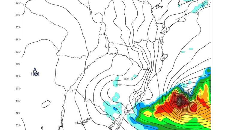
The most affected areas include the southwest, central-west, central-east, southeast of the state of Rio Grande do Sul and the metropolitan region of Porto Alegre
A new extratropical cyclone is expected to form and hit Rio Grande do Sul starting from Monday (27), bringing heavy rain and intense winds. According to MetSul Meteorology, the phenomenon will form due to a low atmospheric pressure system moving from Argentina and Paraguay.
The most affected areas include the south-west, central-west, central-east, south-east of Rio Grande do Sul and the metropolitan region of Porto Alegre.
Winds can reach 60 km/h and there is a possibility of severe thunderstorms. The Civil Protection warns against the risk of floods and landslides, recommending the population to follow the authorities’ instructions and constantly monitor the weather forecast. Preventive measures, such as infrastructure works, are essential to minimize the impacts of cyclones.
Formation of an extratropical cyclone
Extratropical cyclones are common phenomena in mid-latitudes, resulting from the temperature contrast between warm equatorial air and cold air coming from higher latitudes. Although they are most frequent in Europe, North America and Asia, they are also present in South America, including Brazil. This type of cyclone is characterized by strong winds, heavy rain and, depending on the region, even snow.
MetSul explains that these phenomena can last several days and travel long distances. In the case of extratropical cyclones, the energy comes from horizontal thermal contrasts, unlike tropical cyclones, whose energy comes from the evaporation of sea water.
To minimize impacts, it is crucial that authorities carry out infrastructure works and that the population is well informed and prepared to seek safe shelter during the cyclone. Raising awareness of the importance of preventive measures can save lives and reduce property damage.
This meteorological phenomenon highlights the need for continuous monitoring and a rapid and efficient response by the authorities and the population to deal with climatic adversities.
TIME | We have heard several times in recent days that meteorology is not able to predict the moment of the heaviest rain or make hourly forecasts. It doesn’t proceed! The animation shows the evolution of the instability hour by hour at the beginning of the week using our WRF model in the cyclone formation. pic.twitter.com/mdPVQPcOeC
— MetSul #AjudaRS (@metsul) May 27, 2024
Source: Terra
Rose James is a Gossipify movie and series reviewer known for her in-depth analysis and unique perspective on the latest releases. With a background in film studies, she provides engaging and informative reviews, and keeps readers up to date with industry trends and emerging talents.


