The combined weather systems will spread rain across large areas of the South, Southeast and Midwest, easing the intense heat.
The next few days promise a very unsettled weather scenario across much of Brazil, with the combination of several weather systems working together to spread rain across large areas of the southern, southeast and central-west regions. The main factor will be the action of a trough – an elongated area of low pressure – which, together with low surface pressure and advancing cold fronts, will help keep the rain rolling throughout the week. This trend will bring an important temperature regulation, alleviating the intense heat in several regions of the central part of the country.
South: rain returns with force, especially in Rio Grande do Sul
The southern region, after a relatively drier first half of September, will see a significant return of rain in the second half of the month. The highlight goes to Rio Grande do Sul, which is expected to experience a period of more intense rainfall, especially in the western and northern regions of the state. Accumulated precipitation could exceed 70 mm at some points during the week, reflecting the strong influence of the cold front that is organizing in this region.
Santa Catarina and Paraná will also have well-distributed rain throughout the week. In Paraná, the greatest attention is paid to the central-south of the state, where rainfall volumes are expected to be more consistent, while in Santa Catarina practically the entire territory will be affected by this instability. It is possible that the volume of precipitation reaches 50 mm in several areas, especially in the western part of Santa Catarina.
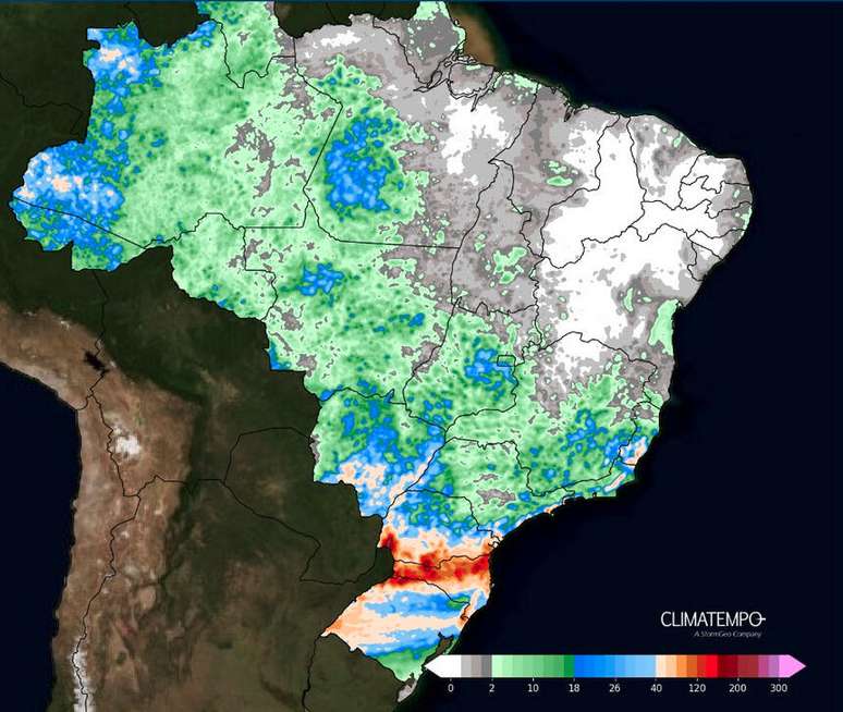
Figure 1- Accumulated rainfall forecast between 7 October and 11 October 2024. Source Climatempo.
Midwest: Rain arrives to ease drought
From mid-week the scenario changes in the central-western region, where areas that have faced a prolonged drought will finally receive rain. Mato Grosso do Sul will be the most benefited state, especially in the central-southern portion, where accumulations could reach 40 mm and, in some localized areas, even exceed this value.
Although rainfall intensity varies between subregions, other areas of the Central West, such as Goiás, Mato Grosso and the Federal District, are also expected to experience significant rainfall. The period of severe drought will be alleviated, which is particularly good for the region’s agriculture and water resources.
Southeast: Instability brings change to dry and hot scenario
In the South-East, the heat will persist across the entire region until mid-week, especially in the internal areas of Sao Paulo, Minas Gerais and Rio de Janeiro. However, with the advance of cold fronts and the reorganization of low pressure, the rains will finally arrive, changing the dry scenario that dominates the region.
From Wednesday until the end of the week, the coastal strip of São Paulo, Rio de Janeiro and Espírito Santo will be the most affected, with accumulated rainfall that could exceed 60 mm in some places, especially on the north coast of São Paulo and in the capital of Rio de Janeiro.
Within São Paulo, rainfall will be more moderate, but still consistent, especially in areas affected by severe drought. The regions of Triângulo Mineiro and southern Minas Gerais will also receive rainfall, albeit with more modest amounts, but sufficient to alleviate dry soil and improve agricultural conditions. Forecasts indicate that these volumes should remain between 20 and 30 mm, helping to reduce the effects of a prolonged drought.
Expectations for the weekend
As the week progresses, the trend is for rain to continue to spread, with low pressure systems acting strongest over the Southeast and Midwest. For the weekend the weather is expected to remain unstable in most of these regions, with locally heavier rainfall.
Source: Terra
Rose James is a Gossipify movie and series reviewer known for her in-depth analysis and unique perspective on the latest releases. With a background in film studies, she provides engaging and informative reviews, and keeps readers up to date with industry trends and emerging talents.


