The exceptional warmth from the Caribbean air is a major reason why Beryl became a Category 5 hurricane earlier than normal.
Hurricane Beryl hit the United States coast on Monday, July 8, after causing damage in the Caribbean. Weather officials say the storm gained “explosive” strength before making history as “the most dangerous Category 5 hurricane ever recorded in the Atlantic.”
For the World Meteorological Organization, WMO, this precedent is alarming for what is expected to be a very active hurricane season, with risks for the entire basin. The situation highlights the need for timely warnings of various hazards.
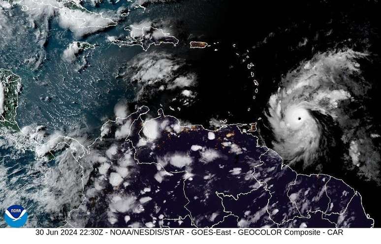
Hurricane Beril and 06/30/24 (Photo: NOAA/CIRA)
Risk of floods and power cuts
North American meteorological authorities have recorded the arrival of Hurricane Beryl on the coast of the southern state of Texas, near the city of Matagorda. Residents have been evacuated due to the risk of flooding and power outages.
It was around 4 a.m. local time that the National Hurricane Center confirmed the storm’s movement ashore about 84 miles (135 kilometers) southwest of Houston, with maximum sustained winds of 80 miles (130 kilometers) per hour.
In the region, residents boarded up their windows and coastal towns were evacuated. More than 1 million people were left without electricity, according to news agencies.
WMO updates focus on humanitarian impacts and are carried out by a coordination mechanism supported by Swiss, German and Austrian authorities.
Caribbean Sea Heat Intensity
Extremely high levels of ocean heat are among the primary reasons Hurricane Beryl became a Category 5 hurricane more than two weeks before any other Atlantic hurricane was recorded.
WMO scientist Philip Klotzbach said the current Caribbean Sea heat intensity is typically felt in mid-September.
According to an observation carried out until May 2024, the region has recorded record sea surface temperatures in the last 14 months.
The central and eastern Atlantic traditionally becomes more active in August, in part because ocean temperatures have been able to warm and fuel developing weather systems. Typically, these temperatures are not warm enough in June and July to favor the evolution of tropical systems.
Strong winds and coastal flooding
The WMO also warns of a possible scenario of a particularly active and dangerous hurricane season for the entire basin involving the Atlantic, Caribbean and Central America.
Beryl caused severe winds and widespread coastal flooding as it moved through the region. In Jamaica, storm surges caused sea levels to rise between 1.9 and 2.7 metres above normal levels, and rainfall totals ranged from 101 mm, 202 mm and even 303 mm.
This week, the United Nations Central Emergency Response Fund made available $4 million to Caribbean authorities to support emergency rescue operations.
Source: United Nations News
Source: Terra
Rose James is a Gossipify movie and series reviewer known for her in-depth analysis and unique perspective on the latest releases. With a background in film studies, she provides engaging and informative reviews, and keeps readers up to date with industry trends and emerging talents.
![Tomorrow Belongs to Us: What’s in store for Friday 31 October 2025 Episode 2065 [SPOILERS]](https://fr.web.img4.acsta.net/img/27/7e/277e1f041c48016486ab18771f578de1.jpg "Tomorrow Belongs to Us: What’s in store for Friday 31 October 2025 Episode 2065 [SPOILERS]")


