Understand the weather situation that caused torrential rain in New York. In less than 24 hours it rained more than the entire month of September.
With Porto Alegre having its wettest September since 1916 and Sao Paulo recording its hottest September in 80 years, the month will end on a high note, with New York completely inundated by a well-above-normal storm.
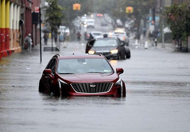
Cars on flooded street in New York due to storm of 9/29/23
(Photo: MTA New York City Transit – Marc A Hermann – 9-29-23 – Public Photos)
New York, one of the most important cities on the planet, found itself defenseless in the face of the colossal amount of rain that fell on it on September 29, 2023. Flooded streets and neighborhoods, flooded highways, flooded airports. The New York subway system had widespread problems because it was invaded by cascades of water coming down the stairs. People stranded, cars adrift.
Due to the storm on Friday, September 29, New York is recording its second wettest September on record, with nearly 350 mm (13.74 inches) dumped on the city. But this heat is preliminary and is expected to increase further with the 24-hour rain recorded this Friday and part of Saturday, September 30th.
Governor Kathy Hochul declared a state of emergency and asked the population to stay at home, given the completely chaotic and dangerous situation that occurred in New York and nearby regions.

Thunderstorm in New York – 9-29-23 Metro-North – View of the Lakeview Road intersection on the Harlem Line
(Photo: MTA New York City Transit – Public Photos)
Fox5 News from the United States reported that this Friday, September 29, 2023, was the wettest day in New York since September 1, 2021, when it rained 177.8 mm in 24 hours (7 inches), during Hurricane Ida.
How much did it rain in New York?
According to data from the NWS, the US National Weather Service, 154.4 mm of rain fell in the JFK airport region in about 12 hours, from midnight to just after noon, Brasilia time. The previous record was 148.1 mm (5.83 in), on 9/12/1960. Registration at JFK began in 1948.
(In the English news about the New York storm you will find the word inches, or for short, in, which means inches, and in Portuguese; 1 inch or 1 in equals 25.4 mm of rain)
In the region of La Guardia International Airportwhich is located in Queens, 14 km from central New York, it rained 217.9 mm in less than 24 hours (8.58 inches), with a normal average rainfall for the entire month of September of 98.5 mm (3.88 inches), according to NWS calculations for the period 1991 to 2020.
The map obtained from the NWS website spatially shows the amount of rain that fell over the New York region and other nearby areas.

Accumulated rain in the New York region in 24 hours, through 6:00 pm (local time) on 9/29/23 (Source NOAA/NWS)
In less than 24 hours more than 100 mm have accumulated in multiple areas of the city, simultaneously, and this is Above average rainfall throughout the month of September. According to the NWS, in the JFK Airport region, the normal average rainfall for September is 90.9 mm. In the La Guardia airport region this average is 98.5 mm.
New York is a metropolis, with many infrastructure problems common to a large city that don’t appear in movies or travel plans, and it couldn’t handle that much rain.
New York Rainfall Volumes on 9/29/23 (Provisional)
Check out other very high volumes of rain recorded in the region near New York, in the states of New Jersey and Connecticut (Source NWS via FOX5).
In New York, the Queens and Bronx regions received the highest volumes of rain
Bronx
Fordham – 6.26 inches 159.0 mm
Harlem – 5.37 inches 136.4 mm
Kings Brooklyn – 7.21 inches 183.1 mm
South slope: 7.18 inches 182.4 mm
Prospect Park – 6.66 inches 169.2 mm
1 N Bay Ridge – 6.28 inches 159.5 mm
Brooklyn College – 5.59 inches 142.0 mm
New York (Manhattan)
Midtown Manhattan – 6.16 inches – 156.5 mm
Central Park – 5.85 inches 148.6 mm (September average=109.5 mm)
Manhattan – 4.66 inches 118.4 mm
Queens
JFK Airport – 8.58 inches – 217.9 mm (September average = 90.9 mm)
Ozone Park – 7.15 inches 181.6 mm
Bellerose – 6.66 inches 169.2 mm
Kew Garden Hills – 6.14 inches 155.9 mm
La Guardia Airport – 4.87 in 123.7 mm (September average = 98.5 mm)
Richmond
Staten Island – 3.32 inches – 84.3 mm
Westchester
New Rochelle – 5.87 inches – 149.1 mm
Connecticut
Fairfield
Greenwich: 5.04 inches = 128.0 mm
New paradise
Waterbury Airport – 3.58 inches – 90.9 mm
New Jersey
Bergen
1 SSE Franklin Lakes – 3.64 inches – 92.5 mm
Hudson
Hoboken – 3.48 inches – 88.4 mm
What caused so much rain in New York?
The reason for the huge amount of rain that fell in the New York region was a cold front associated with low, but slow-moving atmospheric pressure.

Rain over NY – GOES East satellite – NOAA -23/30/9 – 6:46 UTC
The image below shows the synoptic chart of the United States from the morning of 9/29/2023, showing the weather systems that were impacting the country. This type of map is created in all meteorological centers around the world and summarizes the real situation of the atmosphere on the surface.
New York felt the influence of the stationary cold front, with the center of low atmospheric pressure over the New Jersey region.

The synoptic table shows weather systems in the United States on the morning of 9/29/23 (Source: NWS)
Information on the symbols in the synoptic map
The letter L (from low, in English, low) indicates a center of low atmospheric pressure, which in Brazil would be a red B. Low pressure causes moisture to accumulate, resulting in lots of cloud cover and rain.
The letter H (from above) indicates a center of high atmospheric pressure, which in Brazil would be a blue A. High pressure reduces humidity, which reduces cloud cover and the chance of rain.
The colors blue for High and red for Low are international conventions adopted by the World Meteorological Organization.
Curved lines with a blue triangle (ria front) and red crescents (warm front) interspersed represent stationary cold fronts; the dashed brown lines are atmospheric depressions, a region where winds tend to move counterclockwise in the Northern Hemisphere (clockwise in the Southern Hemisphere)
The low-pressure center and stationary cold front that caused torrential rain over New York are moving offshore, moving away across the Atlantic this Saturday.
Source: Terra
Rose James is a Gossipify movie and series reviewer known for her in-depth analysis and unique perspective on the latest releases. With a background in film studies, she provides engaging and informative reviews, and keeps readers up to date with industry trends and emerging talents.


