Know the difference between urban and natural parks […]
Far beyond the most famous urban parks, the city of São Paulo has green areas that not all São Paulo residents know about. But you should.
According to the Secretariat for Greenery and the Environment, the capital hosts more than 100 parks and approximately 40 thousand protected hectares, in eleven municipal Conservation Units.
In this matter, the Travel by fare lists green addresses in São Paulo, managed by the municipality or under concession, which make us forget that we are still in the largest city on the continent. From nature parks in the far south to the first adventure park in the capital São Paulo, these attractions represent a different (and sustainable) way to explore the city.
Urban or natural?
The concept of urban park refers to green areas within the urban perimeter, whose facilities include recreational and sports areas. Aclimação, Ibirapuera, Carmo and Independência are some examples of parks of this type in the capital of São Paulo.
PNMs (Municipal Natural Parks) are Conservation Units that fully protect the green areas of a city and aim to preserve and recover original ecosystems, scientific research and ecological tourism activities.
Units of this group include Itaim, on the borders of the Bororé-Colônia APA, Jaceguava, in the Guarapiranga region, and Varginha, in Grajaú, on the banks of the Billings Dam.
According to Sao Paulo City Hall24% of the municipality is protected as conservation units.
SelvaSP
(Engineer Marsilac)
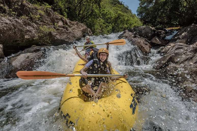
This private park is located in the Capivari-Monos APA, an Environmental Protection Area, in the territory of the Tenondé-Porã indigenous community, in the far south of the city.
The region is home to the largest rural area in the capital of São Paulo and the city’s first and only adventure park.
In Selva SP, a 17,000 m² natural area, you can sail on the capital’s last clean river, hike in the Atlantic Forest and enjoy ecotourism activities such as kayaking, SUP and abseiling.
Structure: parking, bathrooms, monitor service, restaurant with organic products and à la carte meals (weekdays) and self-service (weekends).
Highlights: rafting on the rapids of the Capivari river, a 180 meter long zip line and a route through four waterfalls, in a circular circuit lasting seven hours and three km long.
Estrada do Capivari, 5.005 (Engenheiro Marsilac).
Tel.: (11) 9 4703-9638 / 9 4701-7138.
Every day from 9:00 to 17:00 (closed on rainy days).
Tickets from R$35

Cantareira Forest
(north area of Sao Paulo)
Cantareira is considered one of the largest urban forests in the world and occupies a vast area, between the capital São Paulo, Guarulhos, Mairiporã and Caieiras.
Opened more than 60 years ago, the attraction is recognized by UNESCO as part of the Sao Paulo City Green Belt Biosphere Reserve, a reserve that positively impacts more than 25 million people, across 78 cities in the metropolitan regions of SP , including the capital and Baixada Santista.
One of the highlights is the Pedra Grande Trail, a walk through one of four forest centers that leads to a natural vantage point overlooking the city.
Where: Entrance through door 5 of Horto Florestal (Rua do Horto, 931). We remind you that no animals are allowed inside the park, even with a collar.
The entrance to the Núcleo Águas Claras (Av. Sen. José Ermírio Moraes, S/N – Sítio Barrocada, Mairiporã) is only open on weekends and public holidays. On other days visitors must enter through Pedra Grande.
The beautiful and compact Núcleo Engordador, the historic version of Cantareira, is located on Avenida Cel. Sezefredo Fagundes, 19,100, in Jardim Cachoeira.
When: From Wednesday to Sunday and holidays, from 8:00 to 17:00 (entry until 16:00).
In the months of January and July the Pedra Grande and Engordador centers are open every day.
How much: R$50 / R$25 (half price), with access to the Engordador and Águas Claras centres.

PNM Borore
(Borore Island)
Bororé Municipal Nature Park (PNM) is located far south of the city, on a peninsula of the Billings Dam, an area approximately 80% covered by Atlantic Forest.
One of the curiosities is its access, which can be done via the ancient Estrada do Varginha (current Avenida Paulo Guilguer Reimberg) or via the Ferry Bororé, which connects the Avenida Dona Belmira Marin, in Grajaú, and the Estrada de Itaquaquecetuba .
Structure: parking, bathrooms, naturalized playground for children and panoramic points.
Highlights: Pier on the shore of Billings Dam and on the Aventureiro and Lake trails.
Estrada das Vieiras, s/n, Bororé. Grajaú District, Capela do Socorro Subprefecture
Tel: (11) 5187-0321
From Tuesday to Sunday, from 8:00 to 17:00.
Free Entrance.
PNM Jaceguava
This is one of the green areas that form the Interparques, the largest path in the city of São Paulo. This 100-mile trail connects 11 Southland Conservation Units, including city, state and natural parks, APA (Environmental Protection Area) and RPPN (Private Natural Heritage Preserve).
This park on the banks of the Guarapiranga reservoir was created to offset the environmental impacts caused by work on the southern section of the Rodoanel Mário Covas.
Structure: parking, bathrooms, picnic area and security service.
Highlights: Trilha do Saci viewpoint (approximately 2 km).
Height of number 1,100 Avenida do Jaceguava (Bairro Jaceguava, in Parelheiros).
From Tuesday to Sunday, from 8:00 to 17:00.
Free Entrance.

PNM Varginha
Interconnected with Jaceguava, this 2012 park has 419 hectares and was also created to mitigate the negative environmental impacts caused by the Rodoanel works.
About 30 kilometers from the centre, Varginha is part of the Interparques and is often visited by groups of cyclists.
Structure: parking, bathrooms, ATI (Senior Academy), accommodation for researchers, library, naturalized playground for children, cycle path and viewpoint.
Highlights: Lake, Bromélia Trail, viewpoint on the Içá Trail and dock on the shore of Billings Dam.
Av. Paulo Guilguer Reimberg, 6,200 (Chácara Santo Amaro, Grajaú district).
Tel: (11) 5187-0321
From Tuesday to Sunday, from 8:00 to 17:00.
Free Entrance.
PNM objective
With 470 hectares, the largest PNM in São Paulo is located in a transition zone between the urban area of the Parelheiros district and the more preserved sectors of the far south of the municipality.
In other words, it’s like being in an isolated green area, but easily reachable and without having to leave the capital.
Structure: parking, bathrooms, monitor service, picnic area and children’s playground with naturalized games.
Highlights: Armadillo Trail (700 meters long) and Lago das Ninfeias, a scenic body of water with a large number of these aquatic plants.
Rua Amaro Alves do Rosário, 2676 – Parelheiros (near the Paulus Center).
From Tuesday to Sunday, from 8:00 to 17:00.
Free Entrance.
Serra do Mar
The Núcleo Curucutu is located between São Paulo, Itanhaém, Mongaguá and Juquitiba, and is known for a circuit that brings together three trails: Mirante, Bica and Capelinha.
Of medium difficulty, this 1.6 km route passes attractions such as the historic chapel built by former residents, a landmark between the municipalities of São Paulo and Itanhaém, and an elevated viewpoint which, on clear days, allows you to see the Station Ecológica from Jureia and coastal municipalities such as Praia Grande, Peruíbe and Mongaguá.
With entrance from Marsilac, a district in the extreme south of the capital São Paulo, this park is located about 60 km from Praça da Sé and just 15 km from Itanhaém, on the southern coast.
Source: Terra
Rose James is a Gossipify movie and series reviewer known for her in-depth analysis and unique perspective on the latest releases. With a background in film studies, she provides engaging and informative reviews, and keeps readers up to date with industry trends and emerging talents.

-sok3urr85fed.png "Government announces increase in police force in Rio to “ensure tranquility and right to come and go”")


